ABOUT
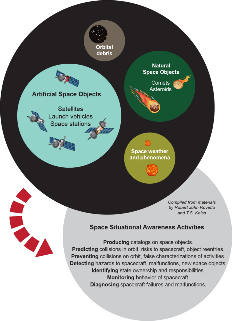
Space Situational Awareness refers broadly to knowledge about the natural and human-made elements of the space environment, which the European Space Agency specifies as “the provision of timely and accurate information regarding the space environment, and particularly hazards to infrastructure in orbit and on the ground.” These hazards could include space weather events and near-Earth objects, which are covered separately. The focus in this document, however, is on the surveillance and tracking of artificial objects in orbit, including space debris, active and defunct satellites, and spacecraft and payloads.
SSA AND SPACE SECURITY
SSA constitutes a vital tool for space governance, monitoring the sustainability of the space environment and ensuring the safety of space assets.
SUSTAINABILITY: SSA increases awareness of negative environmental impacts of human activities in space, such as explosions, collisions, and crowding. Heightened awareness encourages the development of best practices to avoid accidents or other activities that can harm the space environment or other operators.
SAFETY: Because space is a global commons with many different actors and few traffic rules, the collection and distribution of orbital data are critical to the safe conduct of operational activities in orbit and collision avoidance.
SECURITY: Most states view SSA as a military capability that is used to detect potential threats and protect national space systems from intentional harm or collisions. SSA capabilities facilitate anti-satellite capabilities that could be used to threaten adversaries. Yet SSA can also support peace and stability in space when it is used as a tool to distinguish possible space negation attacks from technical failures or environmental disruptions, and to verify capabilities and activities by other actors.
GOVERNANCE: SSA plays a role in political initiatives on space sustainability and security, including voluntary guidelines on the long-term sustainability of outer space. SSA could facilitate verification for potential agreements on arms control and the prevention of an arms race in outer space (PAROS). The ability to verify activities and capabilities of other actors is critical to transparency and confidence-building measures (TCBM) necessary to the governance of space security.
SPACE SITUATIONAL AWARENESS CAPABILITIES
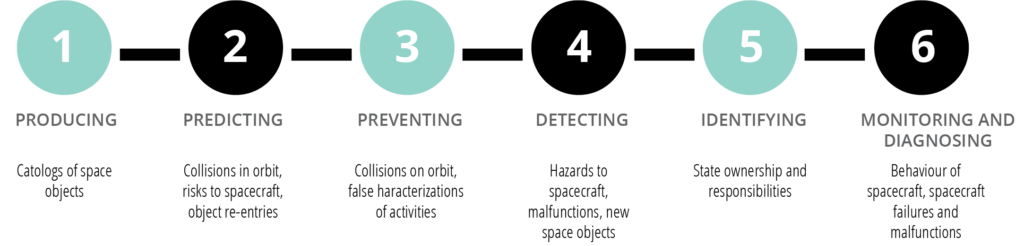
HOW IS SPACE SURVEILLANCE AND TRACKING DATA COLLECTED?
There are many ways to collect data on objects in outer space. Most capabilities are terrestrially based:
• Radar systems measure distances to targets and can track many objects in space simultaneously.
• Optical telescopes, which collect the light or electromagnetic radiation emitted or reflected by objects and generate high resolution images, are particularly useful in tracking space objects that are more than 5,000 kilometres (km) from Earth.
• Some sensors identify radiofrequency or other signals from satellites.
• Lasers precisely measure the distance to a satellite.
• Infrared sensors recognize heat signatures.
Some states and commercial operators are developing space-based capabilities. The Canadian Sapphire satellite system uses sensors in Low Earth Orbit (LEO, less than 2,000 km above Earth) to track and image orbital objects, contributing the data to the U.S. Space Surveillance Network (SSN). Several states have also launched ‘inspector’ satellites, which can closely approach other satellites for surveillance purposes. These capabilities are covered under the theme of security of space systems.
Combining data from many sensors, both terrestrial- and space-based, provides a much more complete picture of the space environment and of activities in space.
WHAT CAN BE DETECTED AND TRACKED?
The U.S. Space surveillance Network (SSN), which provides the most comprehensive identification and tracking of objects in orbit, currently tracks more than 23,000 objects composed of active satellites, defunct satellites, and pieces of debris. Most of these objects are 10 centimetres in diameter or larger.
Objects that are further away from Earth are more difficult to identify, track, and characterize. Currently, only about 1,000 objects are tracked in each of Medium Earth Orbit (MEO, 2,000-30,000 km above earth) and Geostationary Orbit (GEO, 35,786 km above Earth). Although capabilities are improving, objects in GEO generally must be one metre in diameter or larger to be accurately tracked; they cannot be imaged in detail by current ground-based telescopes.
WHO HAS SSA CAPABILITIES?
While all spacefaring nations and even amateur astronomers have knowledge of some orbiting objects, a complete picture of the space environment and of activities in space is beyond the capability of any single actor at present.
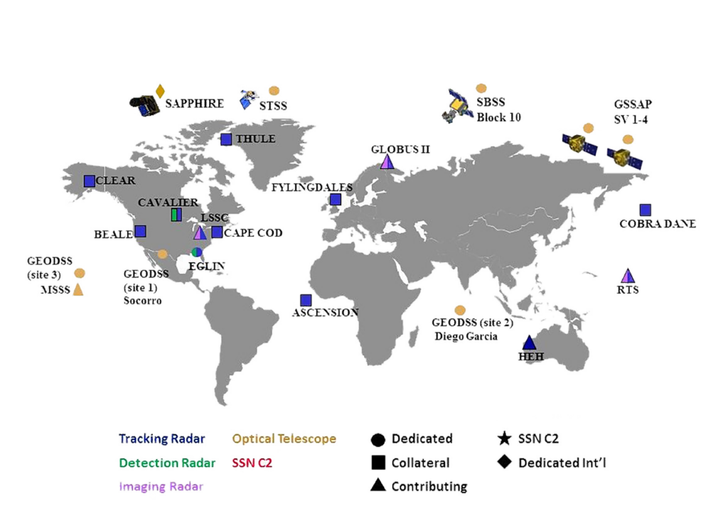
The United States military maintains the most advanced SSA capability through its global Space Surveillance Network, composed of terrestrial radar and optical, as well as space-based sensors. In 2020, a second-generation space surveillance system in the U.S. Marshall Islands, known as Space Fence, became operational. Using radar, it significantly increases the number of objects that can be tracked, and allows for the detection of much smaller objects in LEO.
The Russian Military Space Surveillance Network includes relatively extensive capabilities. It has been updated over the years and includes both phased array radars and ground-based electro-optical telescopes. Russian civilian space agency Roscosmos operates the Automated Warning System on Hazardous Situations in Outer Space, using data from the International Scientific Optical Network (ISON) and other Russian SSA assets.
China has significant satellite tracking, telemetry, and control assets. India and Japan are investing in significant new SSA capability and data-sharing programs, particularly with the United States. European states are acting independently and also together, pooling national capabilities for SSA under a Space Surveillance and Tracking Support Framework that includes both civilian and military components.
Besides these, APSCO (Asia Pacific Space Cooperation Organisation), Australia, Canada, Iran, South Africa, South Korea, Thailand and a number of other states possess some form of SSA capability. It is important to note that ‘capability’ ranges from nascent to developed, and as a result, a plethora of nations possess at least some capacity of SSA.
WHO HAS ACCESS TO SSA DATA?
SSA information sharing is critical for space security. However, because most data collection is military in nature, sharing largely follows patterns of strategic security cooperation.
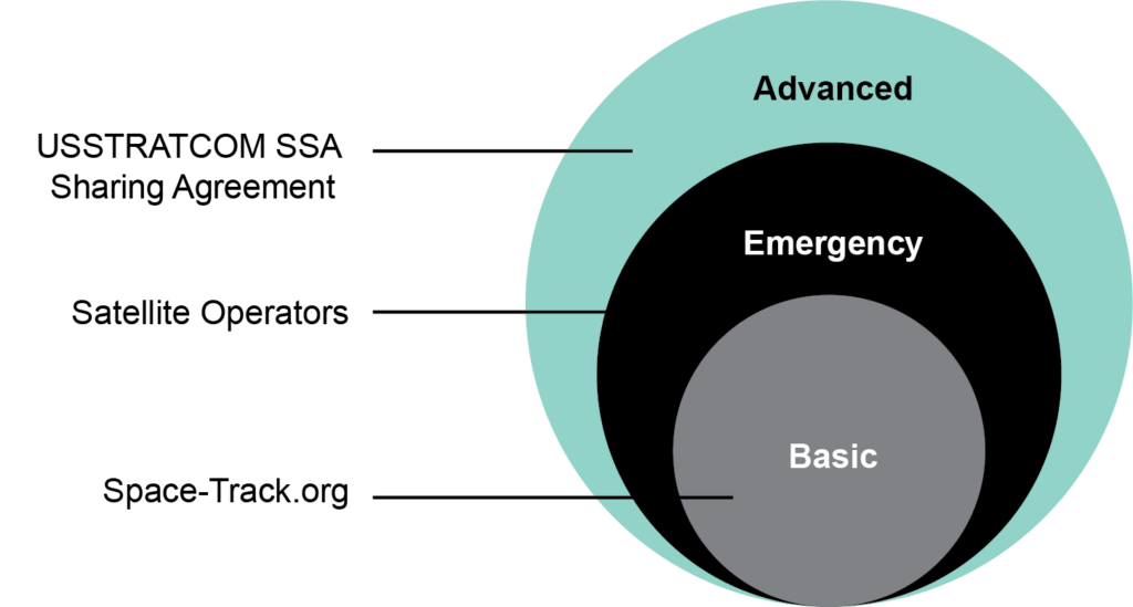
The United States SSA Sharing Program includes strategic defence partners Canada, Australia, and the United Kingdom; it also frequently collaborates with France, Germany, and New Zealand and cooperates closely with Japan. Additionally, this program also provides various levels of safety-support services to 19 states; two European intergovernmental organizations; and more than 77 commercial satellite owners, operators, and launchers. The U.S. website Space-Track.org serves as a public repository of basic satellite catalogue information, including position data and background information, with some U.S. military satellites excluded.
SSA information is also shared through a number of networks and agencies:
• The European Space Agency’s Space Surveillance and Tracking program (SST) is intended to build a collective database, pulling SSA data from all existing European space surveillance systems.
• ISON, a collection of more than 38 observation facilities with 90 telescopes in 16 countries, uses its telescopes to track space objects and orbital debris in Earth orbits, as well as natural space objects. The network collects more than 2 million observations annually and maintains a catalogue of more than 6,000 space objects.
• APSCO is a China-led intergovernmental organizational for space cooperation that includes Bangladesh, Iran, Mongolia, Pakistan, Peru, Thailand, and Turkey as members and Mexico as an observer.
• CelesTrak, a service provided through the Center for Space Standards & Innovation, a research arm of Analytical Graphics, Inc., operates SOCRATES (Satellite Orbital Conjunction Reports Assessing Threatening Encounters in Space), the first public, online conjunction analysis service.
• The nonprofit Space Data Association (SDA) serves as a central hub for sharing data among major commercial participants. It mainly shares data on the positions of members’ satellites and information to prevent electromagnetic interference.
COMMERCIAL SSA DATA
SSA data collection and distribution are being offered as commercial services. Private companies such as LeoLabs, ExoAnalytics, and L3 Applied Defense Solutions operate terrestrial optical and radar systems that collect orbital data. NorStar Space Data Inc. is developing the first commercial space-based system to collect SSA data. Companies including Analytical Graphics Inc. (AGI) collect, visualize, and analyze commercial SSA data to provide private services such as conjunction warnings, trajectory assessments, and anomaly resolutions.
The purveyors of these services have developed private catalogues and databases of orbital objects, with claims that they exceed the capabilities of those published by the U.S. military, particularly for objects in GEO.
GOVERNANCE
There is no global framework to produce and distribute SSA data.
In 2019, the UN Committee on the Peaceful Uses of Outer Space (UN COPUOS) adopted a set of 21 voluntary guidelines for the long-term sustainability of outer space activities. Included in these guidelines are measures to enhance the safety of space operations, including recommendations to:
• share information on space objects and orbital events;
• improve accuracy of orbital data on space objects and enhance the practice and utility of sharing orbital information on space objects; and
• promote the collection, sharing, and dissemination of information on the monitoring of space debris.
TECHNICAL AND POLITICAL CHALLENGES TO COLLECTING AND SHARING SSA DATA
The sheer number of objects in space poses a huge challenge to the complete and accurate collection of data. Small and distant objects pose added difficulties. The tools that states and companies currently use have their own problems.
Radar systems are large, expensive, and complex. They are prone to clutter or frequency echoes and jamming of signals by hostile forces. Optical telescopes require specific lighting and atmospheric conditions to view an object. The always-present aperture diffraction means that they cannot form perfect images. Space-based optical telescopes, still emerging technology, are attempting to resolve some of these limitations but are not there yet.
Data precision is also hampered by the growing number of disparate datasets for SSA, which often differ in the orbital parameters that they report for the same space objects. Then sharing precise and timely SSA data is often impeded because so much of it is produced behind a “military curtain.”
A number of initiatives attempt to compile datasets to allow for greater clarity, transparency, and inclusion. For example, the AstriaGraph project at the University of Texas seeks to create an open-source, collaborative dataset. Lockheed Martin’s proprietary iSpace program allows for an intuitive software suite that amalgamates global optical, radar, and radio sensor information in real-time.
RESOURCES AND FURTHER READING
Space Security Index 2019
https://spacesecurityindex.org/
Satellite Times Space Surveillance
https://celestrak.com/columns/v04n01/
U.S. Stratcom
https://www.stratcom.mil/
United Nations Office for Outer Space Affairs
https://www.unoosa.org
Secure World Foundation
https://swfound.org
European Space Agency SSA
https://www.esa.int/Safety_Security/About_SSA
Bhavya Lal, et al, Global Trends in Space Situational Awareness (SSA) and
Space Traffic Management (STM), IDA, 2018
https://www.ida.org/-/media/feature/publications/g/gl/global-trends-in-space-situational-awareness-ssa-and-space-traffic-management-stm/d-9074.ashx